Azure Maps Weather Services
With an increasing need in all businesses to have the latest and most accurate data, weather is no exception. With Azure Maps Weather Services, you can now integrate weather data into your web or other apps via API. Weather data has been floating around for a while now, but Azure has worked closely with AccuWeather to bring frequent forecast updates (hourly) to you so that you can make better decisions with the data.
As I write this quick update today, here in Calgary, Alberta it is a lovely -8 degrees Celsius with a windchill of -21. For our Fahrenheit friends that is about -6 Fahrenheit with the wind outside. Instead of doing something outdoors, I thought this was a good afternoon to pass along this interesting update from the Azure announcements.
This service provided by Azure, will allow transportation companies to feed real-time weather data into their routing algorithms to help determine actions based on that data. For example: logistics companies have already automated some processes when a snowstorm or snowfall warning is issued for an area, that is incorporated right into your delivery times. Now imagine if you can take this a step further to make routing decisions based on the forecast before bad weather happens. The algorithm could make a logic based decision to not have a truck leave for a certain area that is likely to have severe weather; or even more exciting to alert a driver that there is a higher risk while driving towards a flagged area or route. This can increase delivery time, but also improves on employee safety and dependability – ensuring that the cargo is not damaged and employees have a logistics system that is built to help them improve safety. Lowering risk is one major benefit that can come from this real-time weather data API.
Another example is imagine that you have a crew that is working outside and they need to start a process that must run through completion. Now say this process will take 8 hours but the weather is forecast to be inclement and would impact the outcome of your process at hour 6. You can have an increased amount of weather data that is highly accurate to help you make decisions and increase the chances that your crew will be successful with a positive outcome.

Some of the Azure Maps Weather services that are now in preview that can improve performance and outcomes:
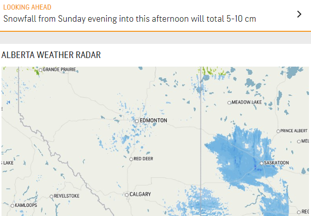
- Weather Tile API:Fetches radar and infrared raster weather tiles formatted to be integrated into the Azure Maps SDKs. By default, Azure Maps uses vector map tiles for its web SDK (see Zoom Levels and Tile Grid). Use of the Azure Maps SDK is not required and developers are free to integrate the Azure Maps Weather Services into their own Azure Maps applications as needed.
- Current Conditions:Returns detailed current weather conditions such as precipitation, temperature, and wind for a given coordinate location. By default, the most current weather conditions will be returned. Observations from the past 6 or 24 hours for a particular location can be retrieved.
- Minute Forecast:Request minute-by-minute forecasts for a given location for the next 120 minutes. Users can request weather forecast in the interval of 1, 5 and 15 minutes. The response will include details such as the type of precipitation (including rain, snow, or a mixture of both), start time, and precipitation intensity value.
- Hourly Forecast:Request detailed weather forecast by hour for the next 1, 12, 24 (1 day), 72 (3 days), 120 (5 days), and 240 hours (10 days) for the given the given coordinate location. The API returns details such as temperature, humidity, wind, precipitation, and ultraviolet (UV) index.
- Quarter-Day Forecast:Request detailed weather forecast by quarter-day for the next 1, 5, 10, or 15 days for a given location. Response data is presented by quarters of the day—morning, afternoon, evening, and overnight. Details such as temperature, humidity, wind, precipitation, and UV index are returned.
- Weather Along Route:Weather along a route API returns hyperlocal (one kilometer or less), up-to-the-minute weather nowcasts, weather hazard assessments, and notifications along a route described as a sequence of waypoints. This includes a list of weather hazards affecting the waypoint or route, and the aggregated hazard index for each waypoint might be used to paint each portion of a route according to how safe it is for the driver. Data is updated every five minutes. The service supplements Azure Maps Route Service that allows you to first request a route between an origin and a destination and use that as an input for Weather Along Route endpoint.
Another benefit of services provided via Azure Maps Weather Services are the potential weather updates you can put in place with the Weather Along Route service. You can create waypoints to get various weather updates along the route as it is in progress live. Azure has derived successful methods and delivery options from a number of their services to provide this easily accessible service.
These new services are available to all Azure customers with enterprise agreements or pay as go services. To start using Azure Maps Services today go to your Azure Portal (https://portal.azure.com) and create your Azure Maps account to start using Azure Maps Weather Service.
Sources:
https://azure.microsoft.com/en-us/blog/rain-or-shine-azure-maps-weather-services-will-bring-insights-to-your-enterprise/
https://docs.microsoft.com/en-ca/azure/azure-maps/zoom-levels-and-tile-grid?tabs=csharp
https://docs.microsoft.com/en-us/rest/api/maps/data
https://www.accuweather.com/en/ca/calgary/t2p/weather-forecast/52479
https://github.com/Azure-Samples/AzureMapsCodeSamples/blob/master/AzureMapsCodeSamples/Bubble%20Layer/Data-Driven%20Bubble%20Layer%20Styling.html